CLICK HERE! For Electronic Services and Online Payment

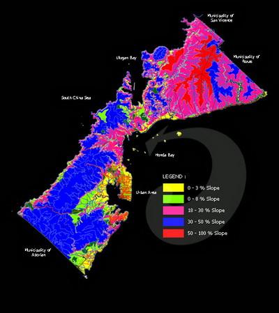
More than half (57.43%) of the total land area of Puerto Princesa City have flat to gentle slopes, making the City an ideal site for urban development and agricultural development (Table II.2). Only about 22% of the total land area of the City has severe limitations for settlements and infrastructure development because of steep slopes (>30%). Moderate slopes of 8-18%, which can also be developed for agriculture and low-density housing comprise 15% of the City’s total land area. However, agriculture and settlements development within this moderate slope range has to adopt soil conservation and slope stabilization measures to avoid soil erosion and landslides, respectively.
Seven (7) barangays have more than 80% of their total land area with flat to nearly level land (0-8% slopes). These barangays are highly suitable for agriculture and urban expansion: Bahile, Binduyan, Concepcion, Langogan, Marufinas, San Rafael and Santa Cruz. Remarkably, Bahile has 98% of its total land area with 0-3% slope.
In contrast, 22 barangays have their entire land area comprised of steep slopes (30-50% slopes). These barangays are better left off with substantial forest cover to maintain their ecological stability and prevent accelerated erosion and massive landslides which could affect downstream settlements, agriculture and coastal fisheries. The 22 barangays sitting on critical slopes are: Bagong Pag-asa, Bagong Silang, Kalipay, Liwanag, Mabuhay, Magkakaibigan, Maligaya, Mandaragat, Manggahan, Maningning, Masigla,Masikap, Masipag, Matahimik, Matiyaga, Maunlad, Milagrosa, Model, Pagkakaisa, Princesa, Seaside, Tagumpay and Tanglaw.
The barangays with the largest area of flat lands (0-3%) include Bahile, Bacungan, Langogan, Napsan, Cabayugan, Marufinas, and Binduyan.
Featured Articles |
USAID/SURGE Project |


